Wednesday, July 31, 2019

Then and Now: Lexington and 33rd Street, NYC

33rd Street at Lexington Avenue, Manhattan

Lexington Avenue at East 33rd Street, NYC, randommusings.;filminspector.com
Lexington and 33rd Street, NYC, in 1974.
New York City is composed of a number of little neighborhoods with a variety of unique names that are very hard to keep straight. I've been a resident for decades and I still have to consult a map to know in which neighborhood a particular street lies. In this article, we are going to Murray Hill, which, as with some other venerable neighborhood names, honors an early resident from the Revolutionary War era. One of the themes of this series of pictures is how little New York City changes over the decades. The common view is that Manhattan is the City that Never Sleeps and that nothing stands still for more than five minutes. Anyone who has lived there for more than a cup of coffee, however, knows that there is an incredible amount of permanence to the Big Apple and the sands of time swirl around and through it without changing much. I found the above photo of midtown from 1974 and decided to do a little investigating on how much the scene has changed over 45 years. So, this is a comparison of Lexington Avenue and 33rd Street in Manhattan from 1974 to 2017.

Lexington Avenue at East 33rd Street, NYC, randommusings.;filminspector.com
Lexington and 33rd Street, NYC, November 2017 (Google Street View).
It turned out to be very easy to find the same spot as the 1974 photo. We are looking north on Lexington Avenue from the Murray Hill area. The Chrysler building on the east (right) side of Lexington is an obvious marker, as is the old Lincoln Building (60 East 42nd Street, now One Grand Central Place since a 2010 name change) on the west (left). The Chrysler building was completed in 1928 and the Lincoln Building in 1930. The buildings on this stretch of Lexington Avenue haven't changed at all. Even the one-way signs on the northeast corner appear the same, although now the one pointing east is on the bottom instead of on top. That's a change for you. Obviously, the Chrysler Buildings hasn't changed, nor has the Lincoln Building, and they are always useful for orienting yourself if you are walking around Midtown South and areas nearby.

Lexington Avenue at East 33rd Street, NYC, randommusings.;filminspector.com
East 33rd Street, NYC, looking west toward the Empire State Building in November 2017 (Google Street View).
I don't know why they changed the name of the Lincoln Building to One Grand Central Place - apparently, it was just to emphasize its closeness to Grand Central Terminal, though that was not explicitly spelled out - but everyone who calls it anything just calls it the Lincoln Building. Incidentally, the Lincoln Building wasn't actually named directly after the nation's President, but instead after businesses named Lincoln including a bank that once were based there back in the day. However, since those businesses were named after the President, that seems like a distinction without much of a difference. I mean, they weren't named after Harry Lincoln or Sam Lincoln or Lincoln Logs or some other Lincoln. It was a clear reference to Abraham Lincoln, a link that the building's owners strongly reinforced for decades until new owners suddenly decided to make the switch. Don't be surprised if someday someone else buys the building and renames it the Lincoln Building, because that at least gave it an identity.

Lexington Avenue at East 33rd Street, NYC, randommusings.;filminspector.com
Lexington and 33rd Street, NYC, November 2017 (Google Street View).
The building to the right is 141 East 33rd Street, known as Stonehenge 33. It is a condo (not coop) finished in 1960. Without getting deeply into the distinctions between condos and coops in Manhattan, condos generally are more expensive because they are easier to rent out and there is no coop board to make your life miserable. Yes, that is a vast oversimplification, but to make it a bit more transparent, in a condo you actually own your apartment whereas in a coop you just lease it. Of course, you actually own it either way for all intents and purposes, but coops are considered slightly more residential since coop boards ostensibly act to make the building more suitable for people who live in the apartment that they own there. It is roughly the difference between owning a house with a Homeowner's Association (HOA) versus one without, but the monthly fees in each are similar. Condos are slightly more preferred by investors, while coops are somewhat more preferred by people who actually plan to live there. Some people prefer one, other people prefer the other, and a whole lot of people couldn't care less as long as they have somewhere to hang their hat. Anyway, someone is probably going to be offended by my description of the differences between coops and condos in NYC, so the bottom line is, just be aware that there is a difference if you ever want to move to New York City. My experience from talking to people in other parts of the country is that most people think that a coop is some kind of grocery store, not a place to live, but Manhattan is funny that way.

Lexington Avenue at East 34th Street, NYC, randommusings.;filminspector.com
Lexington Avenue at East 34th Street, NYC, November 2017 (Google Street View).
The two closest buildings on the left in the 1974 photo are The Murray Park at 120 East 34th Street and, just beyond it, Murray Hill House at 132 East 35th Street (the one with the terraces). This is the Murray Hill section of Manhattan, and, obviously, nobody is looking to rock the boat with creative names for their buildings where a significant portion of their life savings are invested (though I have to admit that Stonehenge 33 does have a ring to it). The former was built in 1962, the latter in 1969. So, everything was settled along this street of Lexington Avenue five years before the original photo was taken in 1974, and probably will be for the next 50 years as well. A time traveler plopped down on the corner of Lexington and East 33rd instantly would know where he or she is, though they might wonder where all the grocery stores went. But, that is a rant for another day.

I hope you enjoyed this entry in our "the more things change, the more they stay the same" series. Residential areas in Manhattan tend to change very little over time, with many of them built solidly in the early part of the 20th Century and likely destined to stand into the 22nd. Please visit our other pages in this series if you liked this one!

2019

Tuesday, July 30, 2019

Then and Now: Peck Slip at South Street, NYC

South Street Seaport Transformation

South Street at Peck Slip, NYC, randommusings.filminspector.com
South Street at Peck Slip, Manhattan, ca. 1981 (Robert Mulero).
Some parts of Manhattan have received a lot of attention over the past few decades but have changed little. That includes everything around the South Street Seaport. Back in the 1970s, it was a dingy, worn-out remnant from the days when it served as a real seaport. While the Fulton Fish Market was still there and operational (as a front organization for organized crime, at least according to the U.S. Department of Justice), everything around it was virtually (or actually) abandoned. The above photo from 1981 brought back memories of that era, so I decided to do a comparison of Peck Slip at South Street in Manhattan from 1981 to 2018.

South Street at Peck Slip, NYC, randommusings.filminspector.com
South Street at Peck Slip, Manhattan, June 2018 (Google Street View).
All of the buildings on the southwest corner of Peck Slip and South Street are intact. However, they look a lot better than they did in 1981. That is due to a massive redevelopment that happened right after the original photo above was taken. In 1982, developer James Rouse began pouring money into the area, which had been first designated a museum in 1967. The entire South Street Seaport area now has been redeveloped and turned into a major tourist destination. Obviously, it was not a tourist destination while in the shape pictured in the 1981 photo.

South Street at Peck Slip, NYC, randommusings.filminspector.com
The Paris Cafe, 119 South Street, NYC (Google Street View).
The ground floor of the corner on the building now houses the Paris Cafe. The sign states that it was established in 1873, but it sure doesn't look like it was in the same place in 1981. It actually has had a lot of famous guests including Butch Cassidy and the Sundance Kid. The Paris Cafe now is a classic Irish eatery with bar at the Seaport that is open to 4 a.m., which makes it a favorite spot of night owls after they've left the clubs. The bar was destroyed by Hurricane Sandy but has been completely rebuilt.

South Street at Peck Slip, NYC, randommusings.filminspector.com
South Street at Peck Slip, Manhattan, June 2018 (Google Street View).
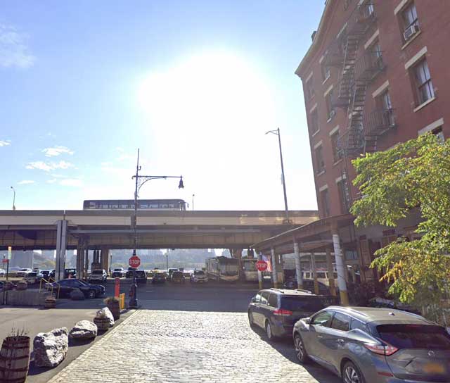
Looking back toward the East River gives a better idea of the location. The highway was there in 1981 and part of it is just visible in the upper left of the original photograph. That section of the FDR Drive, which connects the at-grade parkway north of Grand Street to the Battery Park Underpass and Brooklyn–Battery Tunnel at the southern tip of Manhattan, was completed in May 1954. That year, perhaps not so coincidentally, matches the beginning nadir of the area's fortunes. Since the South Street Seaport area was pretty much derelict by the 1970s, there was nobody interested in parking under the highway as happens today. Plus, the smell of the fish market on the other side made the air in the entire area very pungent. It was a place to drive by, not stop and park and walk into hipster shops. However, the architecture survived and now is in much better shape than it has been for about 100 years.

I hope you enjoyed this entry in our "the more things change, the more they stay the same" series. The South Street Seaport is the same, but different, which pretty much sums up the story of New York City. Please visit some of our other entries in this series!

2019

Sunday, July 28, 2019

Then and Now: Cabrini Blvd at West 181st Street, NYC

Cabrini Boulevard at W181st Street, Manhattan

West 181st Street at Cabrini Boulevard, NYC, in 1969 randommusings.filminspector.com
Cabrini Boulevard at West 181st Street, NYC, in 1969 (Jeff March).
There are many hidden gems among New York City neighborhoods. They are quiet, have great views, and most importantly have stability through the decades. While the commercial areas of New York City often change rapidly, the residential areas often - not always - have more permanence to them. I found the above photograph taken by Jeff March in 1969 and was intrigued by how much it might have changed over the past fifty years. Now, fifty years may not mean much in the grand scope of history, and some European readers might laugh at the notion that anything would necessarily change in such a short time frame. However, in Manhattan, fifty years is a pretty good span of time in which entire blocks can be changed so much as to be virtually unrecognizable. So, I decided to do a comparison of Cabrini Boulevard at West 181st Street in NYC from 1969 to 2018.

West 181st Street at Cabrini Boulevard, NYC, randommusings.filminspector.com
Cabrini Boulevard at West 181st Street, NYC, taken in July 2018 (Google Street View).
The spot in Hudson Heights was pretty easy to find due to the George Washington Bridge looming in the background.  We are standing on West 181st Street just east of the intersection with Cabrini Boulevard, looking west. The original photographer was standing up the fairly steep hill on West 181st Street that runs down toward the Hudson River. He also apparently was using a telephoto lens to sharpen the bridge in the background and underexposed the photo to enhance the view of the bridge. Perspective is everything in actually getting the bridge tower into the shot, a few yards up the hill makes all the difference in whether or not you see it.

West 181st Street at Cabrini Boulevard, NYC, randommusings.filminspector.com
Cabrini Boulevard at West 181st Street, NYC, taken in July 2018 (Google Street View).
The hard part of reproducing the original view isn't finding the proper street corner, it's finding exactly where on West 181st Street the photographer was standing. The view directly above, a few dozen yards east of Cabrini Boulevard, appears to be close to the approximate spot. You can barely see the western arch of the George Washington Bridge in the distance, now partly hidden by trees. Since I can't get the exact angle used in 1969, we'll move around a bit and reconstruct the photo in bits and pieces. The original photo was pretty dark, giving an almost forbidding and claustrophobic feeling to the scene, but it's actually a quite bright and inviting area.

West 181st Street at Cabrini Boulevard, NYC, randommusings.filminspector.com
Cabrini Boulevard at West 181st Street, NYC, taken in July 2018 (Google Street View).
Putting aside the exact position of the bridge, the rest of the view is almost eerily unchanged. I almost expect to see the same people walking across the street fifty years later. The vehicles certainly are a lot smaller and less stylish. That's progress!

West 181st Street at Cabrini Boulevard, NYC, randommusings.filminspector.com
Cabrini Boulevard at West 181st Street, NYC, taken in July 2018 (Google Street View).
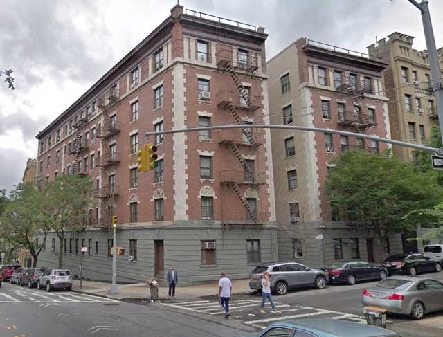
The building on the right with the distinctive windows and fire escapes is 100 Cabrini Boulevard. It was built in 1920, so already was a grizzled veteran fifty years ago in 1969. The George Washington Bridge actually is the newcomer in the scene, having been opened to traffic (upper level) in 1931 and completed (lower level) in 1962.

West 181st Street at Cabrini Boulevard, NYC, randommusings.filminspector.com
Cabrini Boulevard at West 181st Street, NYC, taken in July 2018 (Google Street View).
The buildings on the left (south) side of the street that form the somewhat intimidating wall in the 1969 photograph are connected. They comprise West Gate House at 860 and 870 West 181st Street. Both Nos. 860 and 870 were built in 1923. So, if you are looking for a nice pre-war coop apartment, Cabrini Boulevard and West 181st Street is a good place to begin your search. This obviously is a very stable neighborhood. Anyway, the real estate agents in the area undoubtedly could do a much better job of enhancing the charms of this particular neighborhood, so we'll leave it at that. It's just fun to see an area where someone could be transported fifty years into the future or past and not notice a single change.

I hope you enjoyed this entry in our "the more things change, the more they stay the same" series. Cabrini Boulevard at West 181st Street sure hasn't changed much over the years, and that's undoubtedly just how the residents there like it. Please visit some of our other pages in this series!

2019

Saturday, July 27, 2019

Then and Now: Bonwit Teller at 56th Street and Fifth Avenue, NYC

Bonwit Teller Building on Fifth Avenue
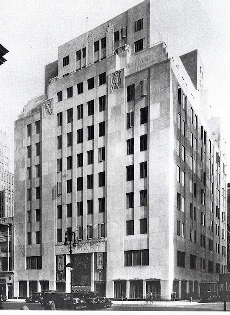

Bonwit Teller building in Manhattan randommusings.filminspector.com
The Bonwit Teller building at 56th Street and Fifth Avenue, NYC.

Sometimes these articles have a political overtone, but that is not the intent: this series is strictly about locations, not people. There are a lot of stylish buildings that have come and gone in New York City. Their artistic merits are debatable, though. Some people will view them as iconic, others as mediocre imitations of good art. One such building was the Bonwit Teller building located on the northeast corner of 56th Street and Fifth Avenue in Manhattan. This story reverberates into the present, so let's take a closer look at it. The above photo of Bonwit Teller's entrance was taken in 1977, but, except for the people and vehicles around it, just as easily could have been taken 30 years earlier. However, the Bonwit Teller building was soon to encounter someone with grander ambitions than just owning a fading department store. Let's make a comparison of the Bonwit Teller building on Fifth Avenue from 1977 to 2018.

Bonwit Teller building in Manhattan randommusings.filminspector.com
Undated photo of the Bonwit Teller building, apparently from the 1950s (HOWARD/AP).

Bonwit Teller was one of a plethora of department stores that originated in Manhattan, grew with the expanding middle class, and then faded and died during the latter half of the 20th Century. The list is massive and includes, among many others, Gimbel's, Alexander's, and B. Altman and Company. The culling process continues to this day, with recent reports that Barney's New York is evaluating bankruptcy options. So, department stores flourishing and then going out of business in New York City is nothing new. Bonwit Teller was founded in 1895 at Sixth Avenue and 18th Street by Paul Bonwit. It was an upscale department store that became famous for catering to the "carriage trade" from its flagship Fifth Avenue location. The changing tastes of the public during the 1980s doomed it, and it is fair to say that Bloomingdale's took away much of its business. Right around the time of the photograph at the top of this page, Bonwit Teller began experiencing growing financial troubles that led to a continuing "musical chairs" type of ownership change. The Bonwit Teller parent company filed for bankruptcy in 1989 and the brand is now extinct.

During its death throws, Bonwit Teller tried to survive by selling its flagship location on Fifth Avenue at 56th Street. This was 1979, and there was a rising power in Manhattan real estate. His name was Donald Trump. Mr. Trump (as everyone with any connection to Trump, er, Mr. Trump routinely called him) had had his eye on the Bonwit Teller property. This was to be Mr. Trump's first major acquisition in Manhattan, coming a year before he bought the Commodore Hotel near Grand Central Terminal and turned it into the Grand Hyatt New York. So far, so good, just a routine NYC real estate transaction, right? Well, not quite.

The 11-story Bonwit Teller building was built in 1929 by Whitney Warren and Charles Wetmore, famous architects more known for the Beaux-Arts Grand Central Terminal. That year was the height of monumental construction in Manhattan, right around the time that the Empire State Building and the Chrysler Building were either just completed or about to be built. The Bonwit Teller building never received nearly the architectural acclaim as Grand Central, but it did have some fancy art deco features. For instance, it had some limestone reliefs of women on the facade which arguably (we'll get to that) were true works of art. Another flourish was the 15x25-foot grillwork over the entrance. Not everyone agreed that these admittedly low-key stylistic flourishes were true art.

Bonwit Teller building in Manhattan randommusings.filminspector.com
Bonwit Teller entrance in 1939 (Wurts Bros. via Museum of the City of New York, 1939).

Among those who considered the reliefs and grillwork artistic and thus worthy of preservation as the Metropolitan Museum of Art. When the Met learned that Mr. Trump was planning to raze the building, it offered a "gift" in exchange for these items. However, the building's new owner didn't agree with the Met's artistic appraisal and wasn't interested in any "gifts" that wouldn't compensate for the cost of preserving the reliefs and grillwork. After casually offering the items to the Met if they could be removed, Mr. Trump's company demolished the building as planned. The grillwork and reliefs were not preserved.

Now, this is not an attack on anyone, particularly not Mr. Trump. He owned the building and had every right to do with it as he wished. That, after all, is what ownership means. The artwork in question wasn't protected because it wasn't particularly distinguished, though beauty is in the eye of the beholder. The preservation movement was in full swing by 1979 and the city had its chance to act if it wished, and it didn't. People didn't come to New York City to see the reliefs or the grillwork completed by artist Otto J. Teegan in 1930. On the other hand, it certainly was memorable to some people and a classic expression of the brief art deco fad that was better expressed in the Empire State Building and Chrysler Building. It turned out that the only opinion that mattered was Mr. Trump's. He later offhandedly called it "junk." As noted above, the artistic value of the building's special touches was arguable, and Mr. Trump had finished arguing about it.

Well, the location of the Bonwit Teller building is the site of a famous building now, more famous than the Bonwit Teller building ever was. It is the Trump Tower. Now, once again, opinions will differ as to the artistic merits of Trump Tower versus the old Bonwit Teller building. However, if there is one site in Manhattan that replaced one iconic structure with an even more iconic structure, it - arguably - is the old Bonwit Teller site.

Donald Trump with model of Trump Tower in 1980, randommusings.filminspector.com
Donald Trump with his model of Trump Tower in 1980.
I hope you enjoyed this entry in our "the more things change, the more they stay the same" series. We strive to be apolitical in these posts and simply report the then-and-now. Thanks for reading and please visit some of our other pages in this series!

2022


Thursday, July 18, 2019

Then and Now: "The House On 92nd Street" in NYC

Madison Avenue at 92nd Street

The House on 92nd Street scenes then and now randommusings.filminspector.com
A scene capture from "The House on 92nd Street" (1945) of the Third Reich flag waving over the German Embassy in Washington, D.C., in 1941.
I love old Hollywood black-and-white films. They give a different perspective on life, one unaffected by modern issues such as the Internet or even in many cases television. Of course, they had their own issues to deal with and we can see how people confronted them. Hollywood motion pictures have been excellent at preserving ordinary street scenes from the past. However, often this resource is overlooked for a variety of reasons, such as the plot of the film being unpopular or the film stock being of poor quality. "The House on 92nd Street" (1945) incorporated some location shooting of areas of Manhattan that now are interesting to those who enjoy looking into the past of New York City. Here, we have a comparison of scenes from "The House on 92nd Street" from its filming in 1945 to 2017.

The House on 92nd Street scenes then and now randommusings.filminspector.com
"Bowling Green" in "The House on 92nd Street."
Some establishing shots in "The House on 92nd Street" have little to do with the plot. For example, there is a nice view of Bowling Green in lower Manhattan. That building now is the location of many offices, including the Museum of the American Indian.

The House on 92nd Street scenes then and now randommusings.filminspector.com
Bowling Green recently (Google Street View).
The small park at Bowling Green has been greatly expanded since World War II. This is a change that has taken place throughout the city. For instance, traffic during World War II used to run under the Washington Square Park arch. Now, the park is purely for pedestrians.

The House on 92nd Street scenes then and now randommusings.filminspector.com

"The House on 92nd Street" was (in the film) the location of a German spy ring in the months before the United States entered World War II. The location (in the film) was just off Madison Avenue on East 92nd Street.

The House on 92nd Street scenes then and now randommusings.filminspector.com
92nd Street at Madison Avenue recently (Google Street View).
The corner hasn't changed much over the years. However, the evocative fire escapes are gone.

The House on 92nd Street scenes then and now randommusings.filminspector.com
Upper floors of the five-story house on 92nd Street shown in the film, which in reality was at 53 East 92nd Street in Manhattan.
The film pans down slowly across the entire building when it is first "introduced." I guess you have to actually show the entire house if you are going to call your film "The House on 92nd Street."

The House on 92nd Street scenes then and now randommusings.filminspector.com
This is the five-story house on 92nd Street shown in the film, which in reality was at 53 East 92nd Street in Manhattan.
The location of the spy ring, disguised as a women's clothing store, was shown in "The House on 92nd Street" only once (aside from incidental views of people entering and leaving the building and so forth).

The House on 92nd Street scenes then and now randommusings.filminspector.com
Here is the hero of the film, William Eythe, standing outside the eponymous house when he first sees it. Note the beautifully wrought iron fence out front. He is emphasizing how tall the building was, though, in fact, it was only of moderate height at five stories.
The building used wasn't actually on 92nd Street at all, but it was close by. In fact, the building shown in the film was exactly one block north at 53 East 92nd Street.

The House on 92nd Street scenes then and now randommusings.filminspector.com
 The spot where the house shown in the film stood is now a pathway to a large building (Google Street View).
Why they changed the location isn't clear. However, a look on Google Street View now shows that the infamous (because of the film) house on 93rd Street where much of the spy action takes place is long gone. Its spot now serves as a back entrance to Carnegie Hill Tower at 40 East 94th Street. Carnegie Hill Tower was built in 1984, so the five-story house shown in "The House on 92nd Street" has been gone for at least that long.

The House on 92nd Street scenes then and now randommusings.filminspector.com
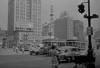
"The House on 92nd Street shows Columbus Circle, with the Adams Building behind it.
The protagonist of "The House on 92nd Street" has his office just off Columbus Circle in the Adams Building at 59th and Columbus Circle. So, there is a nice establishing shot of Columbus Circle in "The House on 92nd Street."

The House on 92nd Street scenes then and now randommusings.filminspector.com
Columbus Circle recently (Google Street View).
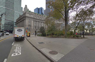
In the 1950s, the large white building that was seen behind the memorial to Christopher Columbus in"The House on 92nd Street" was torn down and replaced by a hideous convention center. That lasted less than 50 years and since has been replaced by a somewhat more attractive complex of buildings. The park around the memorial has been expanded, but traffic still flows around it.

The House on 92nd Street scenes then and now randommusings.filminspector.com

The houses on either side of the eponymous "The House on 92nd Street" are still there and look pretty much exactly as they did then. The same railing that was in front of them remains, though the railing in front of the house for which the film was named was removed whenever that house itself was torn down. If it ain't broke, don't fix it, right? And those are beautiful, upscale homes which have benefited from the growing desirability of the Upper East Side for the wealthy.

The House on 92nd Street scenes then and now randommusings.filminspector.com
The view from in front of the house shown in the film toward Madison Avenue, looking west. That is No. 51 East 92nd Street. The same windows and stairway are visible, along with the railing (Google Street View).
So, while the house that "starred" in "The House on 92nd Street is long gone, the area itself on 93rd Street otherwise is little changed. I hope you enjoyed this entry in this entry of our "the more things change, the more they stay the same" series. If you enjoyed it, please visit other entries in the series!

Below is a copy of "The House on 92nd Street" (1945).


2019

Wednesday, July 17, 2019

Then and Now: White Street at West Broadway, NYC

West Broadway at White Street, Manhattan

West Broadway at White Street, NYC, randommusings.filminspector.com
West Broadway at White Street, NYC, looking south in 1979.
There is a lot more history on display in Manhattan than is apparent at first glance. Everyone notices the big things - the replacement of the Twin Towers, for instance - but there is a lot of unchanging subtlety that you can notice as you walk the streets. This review of a 1979 photo from lower Manhattan concerns some of my personal favorite reminders of the past that usually don't get much attention and which we will get to below. This is a comparison of White Street at West Broadway in TriBeCa in lower Manhattan from 1979 to 2018.

West Broadway at White Street, NYC, randommusings.filminspector.com
West Broadway at White Street, NYC, looking south in November 2017 (Google Street View).
It took a little hunting around to find the exact spot where the 1979 photo was taken, but this looks like it. This is a T-intersection on West Broadway, with White Street running off to the left. The spot was probably chosen for the 1979 concert for that reason, as it would disrupt the least amount of traffic while still providing an open backdrop with gorgeous views in the background. Several of the buildings are the same. Of course, the World Trade Center looming in the background is gone, but you can still just barely see the top of its replacement peeking over another building (which also was there in 1979). This comparison really gives a good idea of how much less space the current World Trade Center takes on the horizon for people looking south than the original World Trade Center did. There is another, more obvious, proof that we have the same location, but it is obscured by the (new) trees. Let's move a little further down the street and you'll see what I mean.

West Broadway at White Street, NYC, randommusings.filminspector.com
West Broadway at White Street, NYC, looking south in November 2017 (Google Street View).
It's still a little obscured, but this view shows the "Goodall Rubber Co." sign that was so prominent in the 1979 photo. Old advertisements painted on the sides of buildings are one of my personal favorite reminders of the past in Manhattan.

West Broadway at White Street, NYC, randommusings.filminspector.com
West Broadway at White Street, NYC, looking south, in 2000.
Above is a photo of the same corner from an unknown date. Beginning in 1911, Goodall's original New York City location was at 12 Gold Street. It was located in that building on the corner, 5 White Street/217 West Broadway. Since Goodall moved into this building a few years before World War II, the sign likely was painted in the late 1930s. Sometimes these signs are painted and then another building is constructed in front of them and they remain unseen for decades, only to be rediscovered when the newer building is demolished.

West Broadway at White Street, NYC, randommusings.filminspector.com
West Broadway at White Street, NYC, looking south, on 6 January 2007 (Wally Gobetz, Flickr).
Here we have proof that the Goodall Rubber Co. sign did not suffer that fate, having survived in the light of day at least since 1979 and undoubtedly for many decades before then. It's an unusual sign, occupying both walls of this corner, made possible by the low building occupied by Goodall on the corner.

West Broadway at White Street, NYC, randommusings.filminspector.com
West Broadway at White Street, NYC, looking south in November 2017 (Google Street View).
The sign says that Goodall Rubber Co. made "Industrial Rubber Products." This is a reminder that once upon a time, lower Manhattan had a thriving manufacturing base. That is mostly gone in the 21st Century, and so is the Goodall Rubber Co. - at least from lower Manhattan. The usual story is that Howard W. Goodall, William S. Feeny, and Frederick D. Stovell, who worked together for another firm in Philadelphia, apparently founded Goodall in 1906. However, other sources say the company was founded in 1870. The company is listed under that name in Hendricks' Commercial Register of the United States, Part 3, of 1891, so the earlier date appears to be correct. Goodall and Feeny had been employed at Latta & Mulconroy Co. of Philadelphia (a distributor of rubber goods) from around 1890, while Stovell had been in the paint and valves business, also in Philadelphia. Apparently, they were just a bunch of friends who one day got together and decided to take their show on the road. Perhaps Goodall's father founded the firm and the younger Goodall simply took over in 1906. Anyway, the origins of the company are a bit murky, but it's definitely been around for well more than a hundred years.

West Broadway at White Street, NYC, randommusings.filminspector.com
A 1945 ad for Goodall Rubber Co., Inc.
The Goodall company moved its Manhattan office to Rutherford, New Jersey, in the late 1970s (like the Giants). So, at the time of the 1979 photo, Goodall had only recently vacated the spot. As of this writing, Goodall is a subsidiary of Lewis-Goetz and Co Inc., headquartered in Pittsburgh PA. It has gotten its money's worth from the cost of those signs.

West Broadway at White Street, NYC, randommusings.filminspector.com
West Broadway at White Street, NYC, looking south in November 2017 (Google Street View).
If you look very closely at the Goodall signs, you can see that they were painted over other signs. You can just make out "Manufacturer of Handkerchiefs" on the left sign. Now, unless people were using industrial rubber for their handkerchiefs in the early 20th Century, some other company had their signs there long before Goodall came along.

I hope you enjoyed this entry in our "the more things change, the more they stay the same" series. Remnants of the past abound in New York City, you see them everywhere, and which survive and which do not often is a matter of sheer chance. Please visit some of our other pages in this series!

2019

Sunday, July 14, 2019

Then and Now: Seventh Avenue at Bleecker Street, NYC

Bleecker Street at 7th Avenue, Manhattan

Seventh Avenue at Bleecker Street, Greenwich Village, randommusings.filminspector.com
Seventh Avenue at Bleecker Street, NYC, in 1979.
This is an interesting picture because of what it shows, but also because of what it doesn't show. History in New York City is in plain sight and yet hidden by lack of memory. The above picture shows Bleecker Street at Seventh Avenue. It is a fairly typical row of houses on Bleecker Street, apparently from the mid-19th Century. You can always tell those apart from more recent buildings due to the cornices - and the fact that they often have the year of construction up near the roofs. Since this photo interested me and shows a slice of Greenwich Village that usually doesn't get a lot of attention, I did this comparison of Seventh Avenue at Bleecker Street from 1979 to 2017.

Seventh Avenue at Bleecker Street, Greenwich Village, randommusings.filminspector.com
Seventh Avenue at Bleecker Street, NYC, in November 2017 (Google Street View).
Our first order of business is always to make sure that we have the right location and compare the structures. Here, it is fairly obvious that we are looking at the same row of buildings, as virtually nothing about them has changed. Well, one thing has changed - the three on the right are painted in noticeably darker colors. That's probably just due to modern tastes, pastels and whites were more fashionable in Manhattan decades ago, whereas now darker is seen as classier or something. One thing that darker colors are better at than pastels is that they tend to show their age less noticeably. So, it's not really a surprise that the pink building in 1979 turned into a dark red, and the tan building to its left turned became an even darker red. Dark red seems to be almost a code for "historic," and one is more likely to consider a 1850s row house as historic in 2017 than in 1979. So, paint it to match the plot.

Seventh Avenue at Bleecker Street, Greenwich Village, randommusings.filminspector.com
Seventh Avenue at Bleecker Street, NYC, in November 2017 (Google Street View).
Let's make a larger point about this scene, however. We're in Greenwich Village, so we know the normal grid rules applied to Manhattan in 1811 don't apply. However, notice the nice view we have of this block of houses (284-289 Bleecker Street). Does that strike you like a little unusual? Usually, in Manhattan, you can't just back up indefinitely to get a better view. However, here we can get a nice long view of these buildings on a side street. What gives? Well, there is a very good reason for this.

Seventh Avenue at Bleecker Street, Greenwich Village, randommusings.filminspector.com
Seventh Avenue at Bleecker Street, NYC, in November 2017 (Google Street View). Bleecker Street is on the right, Barrow Street on the left.
This photo may make the situation a little plainer. Notice the little pizza joint next to the red tenement? Kind of an odd triangular shape. Well, the answer to why this is unusual (and, for Manhattan, it is unusual) is that there used to be quite a different scene here. Back in the early 20th Century, there was no Seventh Avenue at this spot. It ended several blocks north, at 11th Street. However, in 1914, the powers that be decided to extend 7th Avenue south to Varick Street. This enabled the construction of both the new road through the neighborhood and also a subway line underneath it (the New York City Subway IRT Broadway-Seventh Avenue Line, known more familiarly now as the 1,2, and 3 train, opened in 1918). All they had to do was blow up a bunch of buildings just like those four colorful tenements. Oh, and a church or two as well. At that point, those buildings were only about 50 or 60 years old, so who cares, right? Plus, it was kind of a grimy area with a reputation for crimes at the time and the city planners probably saw it as a chance to clean things up a bit. Now, of course, the entire neighborhood would be full of historic buildings if they hadn't made that decision. But, you wouldn't have that nice view of those buildings.

Seventh Avenue at Bleecker Street, Greenwich Village, randommusings.filminspector.com
Seventh Avenue at Bleecker Street, NYC, in November 2017 (Google Street View).
A look down Bleecker Street gives a better view of the impact of the Seventh Avenue Cut (as it was called) of 1914. Notice that building on the right? Barely visible on the right in the 1979 photo, it is somewhat oddly shaped. It wasn't originally built that way. Its end was lopped off in 1914 for the construction of 7th Avenue and the subway. So, after over 100 years, the effects of that decision remain on display. The only reason that the photographer in 1979 was able to get that angle for his or her photograph was because of the 1914 Seventh Avenue Cut. Without it, that building on the right would have been intact and blocked the line of sight. They just sliced off half of the building and built a new exterior wall, and there it remains after over 100 years. Sometimes, the history of Manhattan is revealed more by what you don't see rather than by what you do.

I hope you enjoyed this entry in our "the more things change, the more they stay the same" series. Manhattan is constantly changing, and sometimes what remains acts as a map to what has been lost. Please visit some of our other pages in this continuing series!

2019

Monday, July 8, 2019

Then and Now: 14th Street at 9th Avenue, NYC

Meatpacking District

Meatpacking District, randommusing.filminspector.com
West 14th Street between 9th and 10th Avenues, NYC, in 1976. 
There are few neighborhoods in Manhattan which have changed more than the Meatpacking district. This is an area on the west side of Manhattan that is located on and to the south of 14th Street. Back in the day, it was a rough area, full of rough streets, rough buildings, and some pretty rough customers. When I saw the above picture of 14th Street from 1976, I grew curious as to how much that block has changed in the last 40+ years. So, I decided to do a comparison of West 14th Street between 9th and 10th Avenues from 1976 to 2018.

Meatpacking District, randommusing.filminspector.com
West 14th Street between 9th and 10th Avenues, NYC, in August 2018 (Google Street View).
Our first goal is to make sure that we have the right spot. The north side of 14th Street between 9th and 10th Avenues has changed more than the south side. Many of the buildings on the south side of the street are still recognizable from the 1970s. We can tell that the above photo matches the same location from 1976 because of the distinctive low-slung building in the center of the scene and the larger building at the end of the block which retains the same ornamentation on the roof. Let's take a little closer view.

Meatpacking District, randommusing.filminspector.com
West 14th Street between 9th and 10th Avenues, NYC, in August 2018 (Google Street View).
This photo shows a little more clearly the distinctive roof of the building at the end of the block (on 9th Avenue) and the three-story building a little nearer to us. We have the same spot, all right.

Meatpacking District, randommusing.filminspector.com
West 14th Street at 9th Avenue, NYC, in August 2018 (Google Street View).
Moving a little further to the east, we can see that the red building on the far side of 9th Avenue - the one under the massive water tower - is still there. However, at some point, the owners added a few floors on top. One must admit, they did a pretty good job trying to match the earlier style, but comparing the 1976 photo with the current view shows pretty clearly what was done.

Meatpacking District, randommusing.filminspector.com
West 14th Street between 9th and 10th Avenues, NYC, in August 2018 (Google Street View).
Turning around and looking back toward where the original photographer stood in 1976 shows how much the north side of the street (where he or she was standing) has changed. Until around the last 20 years, there was a low overhang that ran over the street to help shield the workers. The streets were cobblestone, though at some point the city made some attempt to pave them over. The High Line railway, visible in the distance, was still in operation in 1976. Now, of course, it is a park and a "destination." The entire block has gone from being grimy warehouses and a Spanish supermarket (great prices!) to little boutiques and such. I knew a photographer who had his studio in the top floor of one of those buildings on the right, we took a freight elevator to get to his studio (if you see the Robert Redford film "The Hot Rock" - one like that). A great bar, Hogs n' Heifers, was around the corner to the left, and there were gay clubs down by the river. All of that is gone now, it is now a chic little spot where you can get a nice gown for the party at the gallery next week.

Meatpacking District, randommusing.filminspector.com
West 14th Street between 9th and 10th Avenues, NYC, in August 2018 (Google Street View).
A lot the buildings along this stretch of 14th Street remain the same. There haven't been any skyscrapers put in or anything, just some renovations of perhaps questionable taste. Someone suddenly transported from 1976 to 2019 would recognize where they were - though they would be shocked at how clean and neat and tidy it was, especially the north side of the block. However, the spirit and essence of the neighborhood have changed. It is not quite the Upper East Side yet, but it definitely is trendy and being reworked. Money obviously is pouring into the area and gentrification is in full swing. Whether all that change is positive or negative is up to you to decide.

Thanks for stopping by this entry in our "the more things change, the more they stay the same" series. The Meatpacking District no longer has much meatpacking, so it's nice that it has been repurposed at the cost of its grimy, squalid splendor. Please visit some of our other entries in this series!

2019