South Street Seaport Transformation
 |
| South Street at Peck Slip, Manhattan, ca. 1981 (Robert Mulero). |
Some parts of Manhattan have received a lot of attention over the past few decades but have changed little. That includes everything around the South Street Seaport. Back in the 1970s, it was a dingy, worn-out remnant from the days when it served as a real seaport. While the Fulton Fish Market was still there and operational (as a front organization for organized crime, at least according to the U.S. Department of Justice), everything around it was virtually (or actually) abandoned. The above photo from 1981 brought back memories of that era, so I decided to do
a comparison of Peck Slip at South Street in Manhattan from 1981 to 2018.
 |
| South Street at Peck Slip, Manhattan, June 2018 (Google Street View). |
All of the buildings on the southwest corner of Peck Slip and South Street are intact. However, they look a lot better than they did in 1981. That is due to a massive redevelopment that happened right after the original photo above was taken. In 1982, developer James Rouse began pouring money into the area, which had been first designated a museum in 1967. The entire South Street Seaport area now has been redeveloped and turned into a major tourist destination. Obviously, it was not a tourist destination while in the shape pictured in the 1981 photo.
 |
| The Paris Cafe, 119 South Street, NYC (Google Street View). |
The ground floor of the corner on the building now houses the Paris Cafe. The sign states that it was established in 1873, but it sure doesn't look like it was in the same place in 1981. It actually has had a lot of famous guests including Butch Cassidy and the Sundance Kid. The Paris Cafe now is a classic Irish eatery with bar at the Seaport that is open to 4 a.m., which makes it a favorite spot of night owls after they've left the clubs. The bar was destroyed by Hurricane Sandy but has been completely rebuilt.
 |
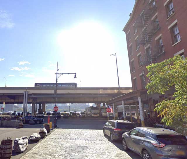
| South Street at Peck Slip, Manhattan, June 2018 (Google Street View). |
Looking back toward the East River gives a better idea of the location. The highway was there in 1981 and part of it is just visible in the upper left of the original photograph. That section of the FDR Drive, which connects the at-grade parkway north of Grand Street to the Battery Park Underpass and Brooklyn–Battery Tunnel at the southern tip of Manhattan, was completed in May 1954. That year, perhaps not so coincidentally, matches the beginning nadir of the area's fortunes. Since the South Street Seaport area was pretty much derelict by the 1970s, there was nobody interested in parking under the highway as happens today. Plus, the smell of the fish market on the other side made the air in the entire area very pungent. It was a place to drive by, not stop and park and walk into hipster shops. However, the architecture survived and now is in much better shape than it has been for about 100 years.
I hope you enjoyed this entry in our "the more things change, the more they stay the same" series. The South Street Seaport is the same, but different, which pretty much sums up the story of New York City. Please visit some of our other entries in this series!
2019


No comments:
Post a Comment
Note: Only a member of this blog may post a comment.