Wednesday, October 31, 2018

Then and Now: 15th Street at 11th Avenue, Manhattan


Then and Now

15th Street West Side Highway randommusings.filminspector.com
15th Street at 11th Avenue, New York City, in 1986.

The above picture of 15th Street at 11th Avenue was taken in 1986. I was curious how the area looks today, so I did a comparison of 15th Street at 11th Avenue in Manhattan from 1986 to 2018. The result using Google Street View is below.

If you are unfamiliar with the general geography of New York City, 11th Avenue is the avenue that runs south along the Hudson River until it turns into West Street around Gansevoort Street in Greenwich Village, just south of the spot in the photographs. Pretty much everyone just calls it the West Side Highway, which was its previous name when Robert Moses completed an elevated highway there following literally decades of construction in 1951. The sad truth of Manhattan is that its leaders never, to this day, have figured out what to do with its waterfronts following the demise of the clipper ships. That problem may never be truly solved.

The West Side Highway (don't ever call it Westway!) itself was a massive catastrophe, lasting barely 20 years in use before lack of maintenance led to its demise in 1973. At the time of the above picture, some portions of the West Side Highway were still waiting to be demolished. However, from here south to the Battery Tunnel, the Westside Highway was long gone by 1986. However, its presence had lasting effects. Rather than being in an area open to sea breezes and the lure of the high seas, lots along the West Side Highway were basically on the "wrong side of the tracks" and had no advantage over areas further inland because they basically were on the outskirts of town.
15th Street West Side Highway randommusings.filminspector.com
The massive West Side Highway under construction in the 1930s (AP).

Regardless of the causes, back in the 1980s, the area immediately to the left (east) of the highway as we are looking down it in the 1986 photograph was mostly bare, with only scattered structures. The highway itself was kind of a jury-rigged affair, with little coherence and largely surrounded by concrete barriers that looked as of they were an afterthought. It's hard to call a roadway which has open parking lots right next to it a "highway." Why that was the case on some extremely valuable property no doubt stems from the area's previous location of the Westside Highway and before then as a seaport. The Titanic as supposed to dock not far from here in 1912. The parking lots and other wasted space along this stretch of the road did not serve very much purpose, but they did at least provide nice views of New Jersey and make the area unlike virtually any other in downtown Manhattan due to its openness and almost suburban character.

15th Street West Side Highway randommusings.filminspector.com
A finished portion of the West Side Highway being used in 1939, during the funeral procession of King George VI. You can see how the highway ate up a lot of ground (AP).

Well, you knew that couldn't last! In 1996, New York finally decided to fix things. The new road was an extension of New York Route 9A, which is its official designation at least for funding purposes (I doubt that anyone casually talking about it ever called it "Route 9A," but there's probably someone who did it in, say, 2011 or something). The new highway is a simple six-lane road with street lights and only a small elevated portion. Construction on it was completed in 2002. Since then, the city and state have spent bundles of money turning the city's western shore into running and biking paths. Most of it became parkland where previously it was just asphalt. The park doesn't seem to have much use - people just go there to walk or jog or blade - but now at least you don't have to jump through small openings between concrete barriers to get to the pathway next to the water (which I had to do many times right around the spot where this photo was taken).

The avenue points directly at downtown Manhattan for most of this journey because Manhattan narrows as you head south. The route was straightened during the redevelopment, making it run in a slightly different direction. Thus, in the above photograph from 1986, you can see the World Trade Center looming over the highway. Obviously, that is gone, and its replacement is behind one of those buildings. The reconstruction project also turned that little parking lot where the shack is located on the left into a small park. Nobody ever seems to be there, at least when I walk by, which makes it sort of like Gramercy Park - a nice idea that nobody actually uses. Why would you want to go there, next to passing cars, when a better park along the water is just across the road?

In any event, the below photo shows that someone is making money off of all this redevelopment. Those large new buildings cost a pretty penny and views of New Jersey ring the cash register. The developers must have just been licking their chops contemplating building condos all along there. To be honest, this area really isn't that much nicer than it was back in the 1980s, but it does look more... orderly. And planned. And sterile. And occupied by the rich. Not that there's anything wrong with that. If you like that sort of thing.

Thanks for viewing this entry in the "the more things change, the more they stay the same series."

15th Street West Side Highway randommusings.filminspector.com
15th Street at 11th Avenue in 2018 (Google Street View).

2018

Then and Now: 83rd and Columbus Avenue, Manhattan


Then and Now

83rd and Columbus in 1983 randommusing.filminspector.com
83rd Street and Columbus Avenue, New York City. This photograph was taken in 1983. 

Looking over the above photograph of 83rd Street and Columbus Avenue in 1983, I wondered what the same street view looked like today. So I did a comparison of 83rd Street and Columbus Avenue from 1983 to 2018 using Google Street View. The more recent photograph is below. I previously did another review of 83rd Street a block over, at Broadway, from around the same time period.

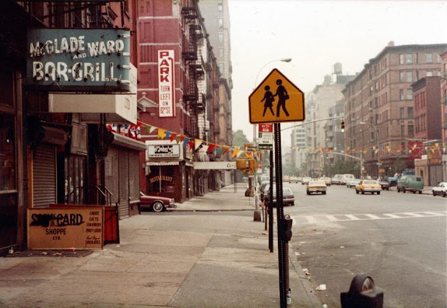
McGlade and Wade Bar and Grill at 83rd and Columbus circa 1979 randommusing.filminspector.com
Another view of the McGlade and Ward Bar & Grill sign (courtesy of Liselight on Flickr). Notice the meat shop next door.

The first thing that I notice is that the buildings haven't changed that much. Almost all of them are the same in 2018 as they were in 1983. The glaring exception is the apartment building in the distance, which towers over the building with the water tank which previously dominated the skyline. However, the red sandstone buildings on either side of Columbus Avenue appear virtually unchanged.

Cilantro and Matsu Sushi, 83rd and Columbus in 1983 randommusing.filminspector.com
Back in the 1970s, things were different here than they were in 2018. Cilantro, on the left, used to be McGlade and Ward Bar and Grill, while the Matsu Sushi location was a butcher shop. The patrons at Cilantro probably get great fish dishes. The more things change...

The stores along Columbus Avenue have changed. McGlade and Ward Bar and Grill at 485 Columbus Avenue was a pretty well-known tavern and may have been the reason this picture was taken in the first place. It moved uptown to 85th Street and then to Amsterdam Avenue under the name McGlade's Snug before finally closing. There was a butcher shop next door to McGlade and Ward's called Jerry's Meat Market. The close association of the two stores gave McGlade and Ward patrons some of the finest, freshest burgers in the city. You drinkers shouldn't despair, though, that corner still has a liquor store, called West Side Wine. The old McGlade's location still has a bar, too, as it is now home to the Cilantro restaurant chain's first location. One can see why it made a good bar, as it has fine wooden beams and flooring.

One thing that is glaringly obvious from the photographs is the presence of trees in the more recent picture. If you ever start feeling wistful for the "old days," just bear in mind that some of the things we take for granted today were completely absent back in the '70s and '80s. The addition of trees here and in other places throughout Manhattan has made it a more liveable city.

There is one noticeable absence in the more recent photograph, too. There are no parking meters in 2018 as there were in the '70s and '80s. Whether you view that as good or bad depends upon your point of view, as now you can't park at all along that stretch of Columbus Avenue. Go find a parking garage or hunt down the side streets.

You may wonder why I am going on and on about a particular bar and grill that is long gone. Well, that may seem to be the small change of the grand scheme of things, but that small change is important in the daily lives of ordinary people. These sorts of places were more important back in the day before the Internet, social media, and cell phones. You actually developed a relationship with a place, knew the bartender, got interested in the owner's "story," and took your friends there. Now, of course, it is customary to grab a burger or something and take it home or on the run for the most part, whereas dining and imbibing was a more leisurely activity back in the day. There are a lot of people who miss specific places like McGlade & Ward's Bar & Grill.

Thanks for visiting this offering in my series about "the more things change, the more they stay the same."

83rd and Columbus in 2018 randommusing.filminspector.com
83rd Street and Columbus Avenue, New York City. This photograph is courtesy of Google Street View as of 2018 (Google Street View).

2018

Then and Now: West 26th Street at Seventh Avenue, Manhattan


Then and Now

26th Street and Seventh Avenue in the 1980s randommusings.filminspector.com
26th at Seventh Avenue, Manhattan, New York, 1980s.

I found the above photograph of West 26th Street and Seventh Avenue in Manhattan, New York from the 1980s (I don't have a better date than that) and wondered what the same corner looked like 40 years later. So, I did a comparison of West 26th Street at Seventh Avenue in Manhattan between the 1980s and 2018. The resulting photograph from Google Street View is below.

In a sign of the times, the little store on the corner in the 1980s (which apparently was leaving) has been replaced by a Chipotle. Notice that the 1980s store has an iron grating to protect it, which was quite common in the 1980s. It is doubtful that the Chipotle has anything like that. However, the Chipotle's security is built-in, as the plate-glass windows of the 1980s store largely have been replaced with solid walls. The stores of the 1980s generally were built with a more open style featuring expansive windows, and not like the mini-fortresses of today. To be fair, the Chipotle store is very tastefully done, and you can hardly tell that it also is a more secure store now.

A lot of New Yorkers these days complain that the focused little stores of yesterday which sold appliances and furniture and things like that are rapidly disappearing. They are being replaced with the Chipotles of the world, small stores featuring high traffic that feature things that you can't really buy online (like a hot tamale). The corner of West 26th Street at Seventh Avenue is a perfect illustration of that trend.

The building itself is the same, as are the buildings on the other side of the street all the way into the distance. The streetlamp is in the same place and, who knows, may even be the same one. The postal box is gone, of course, a victim of 9/11 security measures. Really, aside from those details and others like the different crosswalk painting, this view looks almost identical to the one you would have seen in the 1980s. However, the corner undeniably is cleaner in the later photograph, there was a lot more random trash in the gutters in the 1980s and earlier.

This is another in my series of "the more things change, the more they stay the same" comparisons. The corner of Seventh Avenue and 26th Street definitely is one where a visitor from the 1980s would feel right at home and would barely notice a difference, though he or she might wonder what that Mexican restaurant on the corner served.

26th Street and Seventh Avenue in 2018 randommusings.filminspector.com
West 26th Street at 7th Avenue ca. 2018 (Google Street View).

2018

Then and Now: East 58th Street, Manhattan

Then and Now

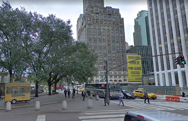
58th Street at Fifth Avenue, Manhattan, in 1979 randommusings.filminspector.com
58th Street at Fifth Avenue, Manhattan, in 1979. Note the Playboy building in the background.

I found a snapshot of the Playboy Club taken in 1979. This led me to compare East 58th Street at Fifth Avenue in 1979 with 2018. I like to compare the same locations from different eras to see what has changed and what has stayed the same.

In the 1979 shot, you can see the Playboy building at the far right. However, that building is gone now and they are looking for new tenants. The Sherry-Netherland Hotel building on the corner built in 1927, of course, is still there, starting the unyielding row of masonry that runs up toward Harlem. That building is unlikely to disappear anytime soon, considering that it is within the Upper East Side Historic District, created in 1981. Of course, the Historic District didn't save the Playboy building, but it didn't have quite the imposing historical presence of the hotel next door.

I like to look for the little details that have stayed the same as well as the buildings. It would not surprise me if those were the same trees standing in Grand Army Plaza, and the stanchion and arm for the traffic lights look suspiciously similar, too. They already had the "Don't Walk" signs in 1979, but that appears to have been replaced with a new one.

While it is almost entirely out of frame in the 1979 photograph, the General Motors Building to the right was there in 1979, having been built in 1968. From 1998 to 2003, future President of the United States Donald Trump and partners owned it. Trump removed the silly sunken plaza in front of the GM Building (which is what everyone calls it) that did nothing for the area and interrupted the smooth level space that extends from the General Motors Building over to the Plaza Hotel. The Plaza (which is what everyone calls it) is out of view to the left (which Trump also owned at one point, but not at the same time as the General Motors Building).

Anyway, that pretty much sums up what you can see in the 1979 shot. While the style of taxis has changed, there they are in both pictures, and, to be honest, it wouldn't phase me at all if one of those 1979 jobs pulled up to give me a lift today - well, aside from the fact that I'm not in New York right now!

This is part of my series of "Then and Now" comparisons. As these photos prove, the more things change, the more they stay the same. Thanks for visiting.

58th Street at Fifth Avenue, Manhattan, in 2018 randommusings.filminspector.com
58th Street at Fifth Avenue, Manhattan ca. 2018 (Google Street View).

2018

Then and Now: 50th Street at Broadway, Manhattan


Then and Now

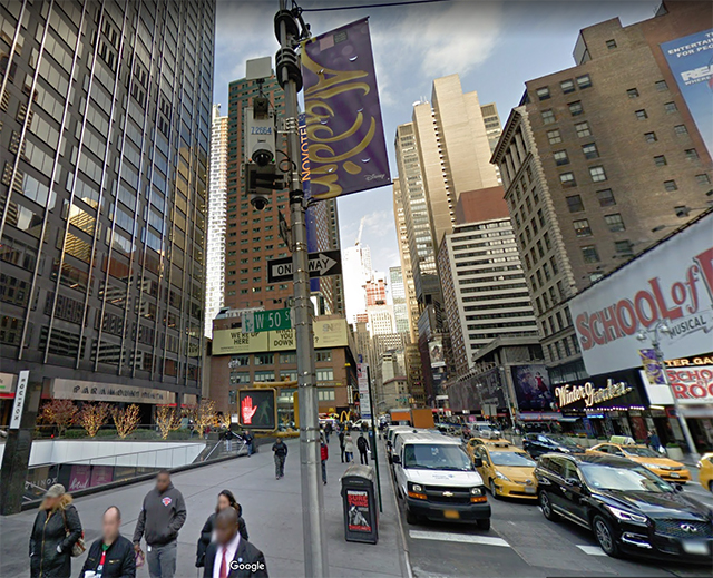
Broadway and 50th Street in NYC in the 1970s randommusings.filminspector.com
Broadway and 50th Street, New York City, in the 1970s.

The area around 42nd Street up to about 52nd Street is known collectively as "Times Square." It is one of the most heavily trafficked areas on earth, constantly swarmed by pedestrians throughout the day and long into the night. I saw the above picture from the 1970s and decided to compare 50th Street and Broadway in Manhattan from the 1970s to 2018. There is a recent picture from Google Street View below for comparison.

When you compare the two pictures, it is easy to say, "Well, they're completely different." However, take a closer look. Despite the passage of 40 years in one of the most valuable areas of real estate in the world, there is a lot that remains the same. Let's look at a few things.

Directly in the middle of the 1970s photo in the distance is the MONY (Mutual of New York) building. It is still there, and you can see it as the brown building with a red building seemingly sprouting from it. The building no longer says "MONY" on it, but instead has the street number - 1740 - where "MONY" used to be. It's hard to see in the Google Street View, unfortunately, but that's really a testament to the skill of the photography 40 years ago.

The brown building at left-center, a block away, also appears to be the same. However, it looks like the put an additional floor on it.  The brown building to the right, which is right behind the stoplight in the 1970s picture, also is there, and it appears completely unchanged. Most of the other buildings, however, appear to be different. Some of the owners of the non-skyscrapers probably made a killing by selling their air rights to the newer buildings up the road. Unfortunately, the area directly to the left in the 1970s shot is cut off, but I'm pretty sure they didn't have escalators there back then.

There also is a more subtle change regarding the people in the shot. In the 1970s photo, there are plenty of red, blue, and yellow coats. In a nutshell, people were unafraid to show a little style. In the more recent photo, you get different shades of black and grey aside from occasional red ties and white-ish sweatshirts. It's not exactly the death of style, but it's the death of vivid colors as ordinary everyday wear. People don't want to stand out the way they did in the 1970s - it makes you a target.

Anyway, I hope you enjoy these comparison shots. They are intended to show that, even in the city that never sleeps, the more things change, the more they stay the same.

Broadway and 50th Street in NYC in 2018 randommusings.filminspector.com
Broadway and 50th Street ca. 2018 (Google Street View).

2018

Tuesday, October 30, 2018

Then and Now: Minetta Lane in Manhattan


Then and Now

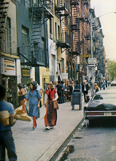
Minetta Lane 1970s randommusings.filminspector.com
Minetta Lane in the 1970s.

I stumbled on this picture which is only identified as "From the 1970s." Well, all one has to do is look at what those ladies are wearing and you could pretty much figure that one out. Fortunately, the picture also shows the street name - Minetta Lane - and there's only one of those in New York City. So, I decided to do a comparison of Minetta Lane in the 1970s and in 2018.

Anyway, for some reason, Google Street View doesn't have a very good view of MacDougal - the street we are actually looking down -  and Minetta Lane. However, I did the best I could, and I think this view is actually a bit better than the original one in terms of getting a feel for the location. In both instances, the photographer is standing in front of Cafe Wha? and Player's Theatre. You know it's high class if it's spelled Theatre, by the way.

You can tell we're in roughly the same spot by the fire escapes and those arches you can just make out on the building down the street to the left. The added trees, which really creates a more mellow view than the stark one in the 1970s and changes the entire character of the neighborhood. They really look like two different streets to me - but yes, they are the same spot. The above photo is a great example of how a forced perspective can transform a quiet, charming little byway into a busy city street.

As usual in New York City, there are some striking remnants of the past. The streetlamp appears to be the same one - I don't think they replace those unless they fail. The one-way sign on the streetlamp also appears to be in the same spot, if not the very same sign. I don't know how long things like that last, so if they change them every decade, so be it, but they look the same to me. The street curbs also look the same, and those building facades certainly look untouched for 40 years. Buildings in Greenwich Village are protected if they have any historic value, and that likely applies to some of these if not all of them.

Anyway, this is another in my series of "the more things change, the more they stay the same" comparisons. I hope you enjoy it!

Minetta Lane circa 2018 randommusings.filminspector.com
Minetta Lane in New York City circa 2018 (Google Street View).

2018

Then and Now: Broadway at 83rd Street, Manhattan, New York


Then and Now

Broadway and 83rd Street in the 1970s randommusings.filminspector.com
Broadway and 83rd Street in the 1970s.

Some things never seem to change. Such is the case for the small pedestrian parks on the Upper West Side of Manhattan. Having found the picture above from the 1970s, I decided to do a comparison of Broadway and 83rd Street from the 1970s to 2018.

The result taken from Google Street View is below. As you will notice, orientation is correct because of the distinctive window pattern on the building in the background. A lot of things may change on a building, but a window pattern seldom does.

A few things are obvious from the picture. The city removed the trees behind the seating area, perhaps to improve driver visibility. Signage also has been reduced, perhaps for the same reason. The city also removed the trash can across from the benches, perhaps for health reasons - it appears the one there in the 1970s is overflowing. The two poles holding traffic lights on either side of the benches appear to be the same, as are the concrete barriers. It's pretty remarkable if none of those had to be replaced after 45 years of constant traffic.

Broadway and 90th Street in 1981 randommusings.filminspector.com
This photo from Broadway and 90th taken in 1981 shows that these benches were quite popular back in the day. The trash cans were still there, too.

All in all, the modern version looks cleaner, more orderly, more rational, and somewhat antiseptic and barren. Still, they do still get some use, as the below photo shows. It's a wonder that people like to sit in those areas with traffic constantly driving by, but old photos show the benches - which are on many streets in the area - to have been quite popular.

Anyway, this is another in my series of "the more things change, the more they stay the same" photos. I hope you like them!

Broadway and 83rd Street circa 2018 randommusings.filminspector.com
Broadway and 83rd Street ca. 2018 taken from Google Street View.

2018

Then and Now: 30th Avenue and 31st, Astoria, Queens, NYC


Then And Now

Astoria, Queens in 1981 randommusings.filminspector.com
30th Ave and 31st St,  Astoria, Queens, New York City, 1981.

The "outer boroughs" of New York City don't usually get a lot of love when looking at the New York City of the past. Above is a street scene in 1981 of 30th Avenue at 31st Street, showing the station for the N/W trains.

I decided to compare 30th Avenue at 31st Street in Astoria, Queens from 1981 to 2018. I used Google Street View of the exact same location. The essentials are the same - the elevated railway, the street and store layouts, even apparently the floral shop in front of the bus - but there is one key difference that intrigues me.

Notice the Optimo Cigars sign on the left behind the bus (which itself is interesting for being so vintage). That is known in the business as a "Privilege Sign." Privilege signs are given out by major manufacturers to stores to push their products. The signs were called "privilege" because, while they always named the manufacturer's product and served as a form of advertising, the store owner (who got the sign for free) could usually add some of their own products to it.

The privilege signs supplied by the Optimo Cigar Company were everywhere in New York back in the day. Optimo was founded by Antonio Santaella, who was originally from Andalucia, Spain and became a cigar maker in Cuba during the 1870s. In 1886, Santaella went to Chicago, Illinois to open a factory. There he produced many popular brands of cigars. These included Optimo, Marquette Club, Reformador, and Flor de Cervera. Optimo was the favorite cigar brand of Babe Ruth, among other celebrities, and apparently was the company's favorite offering overall. The Optimo Cigar Company prospered in the 1950s and began providing Privilege Signs. The Optimo Cigar Company is still very much around, and in fact apparently is doing quite well in the midst of a sort of mini-renaissance of cigar smoking. However, it appears to have gone out of the "free sign" business.

Astoria, Queens in 1981 randommusings.filminspector.com
An Optimo Cigars newsstand on 14th Street in Manhattan. Some small establishments like this simply called themselves "Optimo Cigars Newsstand" or some variation of that to take advantage of the free sign.

Anyway, the Optimo Cigars signs are fading away, as did the one at 30th Avenue in Astoria. They used to be everywhere - you couldn't walk a block in many neighborhoods without seeing one somewhere - but now there aren't nearly as many. The street corner is still the same, and while there isn't an Optimo sign there - the store itself is still a typical streetcorner place selling the same sorts of products.

This is another in my series of "the more things change, the more they stay the same" posts. I hope you like them!

Astoria, Queens in 2018 randommusings.filminspector.com
30th Avenue and 31st Street, Astoria, Queens on Google Street View in 2018 (Google Street View).

2018

Then and Now: 5th Precinct, Manhattan, New York


Then and Now

5th Precinct in Manhattan in 1979 randommusings.filminspector.com
The 5th Precinct, 19 Elizabeth Street, New York, NY, 10013

The above picture was taken in 1979. It shows the 5th Precinct in Manhattan, located 19 Elizabeth Street. It covers Chinatown, Little Italy, and the Bowery. It is not one of the better-known Precincts, such as the 9th Precinct which was used as the setting for "Kojak" in the 1970s. However, the 5th Precinct was the one depicted in the film "Gangs of New York" and later played a key role during the Tong wars of the early 20th Century.

However, low profile or not, the 5th Precinct is historic. The city broke ground for the building in 1879 pursuant to the design of Sergeant Nathaniel Bush, who was the department's architect from 1862 to 1895. The building was completed in 1881, replacing some terrible tenements. That's a pretty long run, and his buildings have stood the test of time. The 5th Precinct, by the way, originally was the 6th Precinct until 1924, when it became part of the 3rd Precinct, and then changed again in 1929, when it was redesignated for good (so far) as the 5th Precinct. It's a good thing that Sgt. Bush put the year of the building above the doorway and not the number of the Precinct!

The police department decided to "upgrade" its stationhouses in the 1960s. However, local community opposition prevented it. You have to admit that keeping the same building was a cost-effective solution considering that it is still in use in 2018. A replacement building itself would be aging by this time.

Incidentally, at the time the above picture was taken in 1979, the 5th Precinct building was still heated by coal as it originally was in 1881. Yes, they would have a truck pull up and load coal into the chute, and someone in the basement would have to stoke coal into the furnace. Since then, however, the station has been modernized and no longer uses coal.

You are perhaps thinking to yourself, well, what is the point of this comparison of the 5th Precinct in Manhattan from 1979 to 2018, nothing at all has changed. Well, that is the point. New York City is often called "the city that never sleeps" and is always changing, but, in fact, many key parts of the city never change at all. The police department stationhouses are one of those unchanging parts. You could have stood in that same spot in 1881 or 1918 or 1979 or 2018 and seen exactly the same thing aside from the vehicles and fashions of the people there.

Anyway, this is part of my "the more things change, the more they stay the same" series. I hope you like it.

5th Precinct in Manhattan in 1979 randommusings.filminspector.com
The 5th Precinct ca. 2018 (Google Street View).

2018

Then and Now: East 34th Street, Manhattan, New York


East 34th Street in Manhattan, New York in 1979 randommusings.filminspector.com
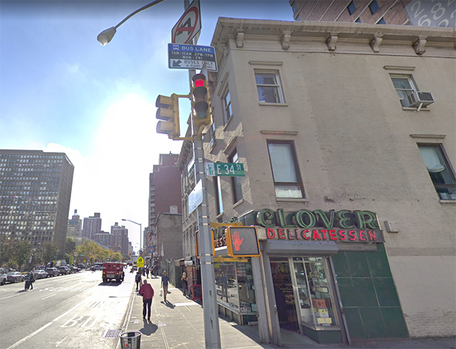
The corner of East 34th Street and 2nd Avenue, Manhattan, 1979.

As these things go in Manhattan lore, the above picture of the corner of 2nd Avenue and 34th Street in New York City is fairly well known. It was taken in 1979, and it shows the old Clover Delicatessen with a striking billboard that obviously caught the photographer's eye. You know how those old delis were, all gone, they don't make 'em like that anymore, right?

Well, it turns out that they don't have to make 'em like that anymore because the Clover Deli is still there and bigger and brasher than ever. I decided to do this comparison of East 34th Street and 2nd Avenue from 1979 to 2018 using Google Street View. The resulting picture is below.

There are several things about the comparison that really strike me. One is that, while the old "I like my Independence (Savings bank)" billboard may be long gone (along with the bank itself, which went public in 1998 and was acquired by Santander in 2006), the spot for the billboard is still there. I'm a bit surprised they can't find a customer for that spot, that's still a prime location. I'm not sure why the Deli was closed in the 1979 picture - maybe they closed on Sundays? - but the deli itself is still there with lights blazing in the 2010s. It appears the same vintage deli signage is the same. It appears they shifted the street lamp over the avenue, but it still looks quite similar to the one in 1979. I'm not enough of an expert on street lamps to know if they try to keep the same styles or what, but they sure do look similar. The view down Second Avenue (looking south) is very similar, too.

Really, if you took a walk there in 1979 and were instantly whisked to 2018, you would still feel perfectly at home and would barely notice any changes.

Anyway, this is just another entry in my "the more things change, the more they stay the same" series. Hope you enjoy it!

East 34th Street in Manhattan, New York in 2018 randommusings.filminspector.com
East 34th Street and 2nd Avenue ca. 2018 (Google Street View).

2018

Then and Now: East 64th Street in Manhattan


East 64th Street in 1972 randommusings.filminspector.com
East 64th Street and Second Avenue, New York, New York, mid-1972.

Those of us who have lived in New York City know how little the city really changes over time. Oh, sure, there are always new styles and cars and businesses and politics and people and all that. New York City is like a raging river. However, the city itself - the riverbanks, if you will - has an inertia and solidity that cannot be denied.

Case in point: the above picture was taken in 1972 at the corner of East 64th Street and Second Avenue. This, incidentally, was only a few years before Jack Lemmon's "The Prisoner of Second Avenue" (1975) was filmed. That area was considered quite chi-chi back in the day, the place for up-and-comers who hadn't really quite made it all the way to Park Avenue yet. Anyway, the above photograph is an ordinary street scene from almost fifty years ago at the time of this writing.

I was curious how much this particular corner of the universe has changed. Why not do a comparison of East 64th Street in 1972 and in 2018? So, I went in and poked around on Google Street Maps, trying to find the same corner (I did not know the avenue). And, lo and behold, the below picture is what I found.

Now, obviously, there are some differences. Manhattan is known as an ever-changing city where buildings go up and down in a heartbeat and everything is fluid. So, the pedestrian crosswalks are painted a bit differently, the street sign is a different color, and the cars are your typical little 2010s teardrops. However, that streetlight and stanchion - aren't those the exact same ones? Those buildings haven't changed a lick, not even the color, the windows are still the same. Even the building way down yonder sticking up like a sore thumb in the distance seems immutable, though it seems a little higher from this perspective.

The little Allen Carpet storefront is still there, though the location appears to be vacant now. It looks like they added some window-space on the 64th Street side at one point, you can see where the addition starts. You can buy your carpets cheaper online these days, I suppose. In a way, that is a sign of the times, many people are commenting on how ordinary stores like a carpet place can no longer survive in Manhattan. You have to be a fast food place or something like that these days to get the traffic to afford the rents.

I was pretty surprised when I made this comparison. Even I expected more would have changed over almost five decades than that. It would not surprise me in the least if some of the people who lived in that building on the corner still live there to this day - once people get comfy in NYC, they tend to stay put. I've had the same place in Manhattan since 1993, but that's nothing in comparison to some people who have been there decades longer. I'm still like a newcomer compared to a lot of denizens of Manhattan.

There are people who love to look at old photos and videos on Youtube and comment morbidly, "Well, they're all dead now," as if they've just discovered Uranium. I'd bet you good money, though, that somebody in that building or the one next to it in 1972 still lived there in 2018, maybe a kid in a family or a young executive in his 20s who had found his niche by the early '70s and decided he simply liked Manhattan's East Side. Oh, and the permanence of rent control wouldn't hurt my bet prospects, either.

Anyway, this is not meant to be some deep examination of social change or anything like that. It's only a momentary rumination on the fact that the more things change, the more they stay the same.

East 64th Street in 1972 randommusings.filminspector.com
East 64th Street at 2nd Avenue ca. 2018 (Google Street View).


2018